CHOCHOCOUANE RIVER CANOE TRIP LOG
July 2-8, 2000
Submitted to Scouts Canada for
the Amory Award competition
21st Nepean Venturer Company
CHOCHOCOUANE RIVER CANOE TRIP LOG
July 2-8, 2000
Submitted to Scouts Canada for
the Amory Award competition
21st Nepean Venturer Company
The 21st Nepean Venturer Company is made up of individuals from
the Trend-Arlington and Craig Henry regions of Nepean and
individuals from the Glebe region in Ottawa. The company is one
of the largest and most active companies in all of the Voyageur
region. We are known throughout the community for our volunteer
work at food drives and various scouting functions, as well as
our annual Crazy Canuck Car Rally which is just one of several
camps we organize for the region throughout the year. We organize
2 white water canoe training courses as well as participate in
them so it was only fitting that our trip involves white water
canoeing.
Our company consists of the following members:
Christy Ashton
Courtney Ayre
Alex Dearham
Geoff Garrett
Sean Harris
François Kunstmann
Chris Jones
Marc Lindell
Pam Louie 1
Dan Shore
Evan Van Neste
Our company is aided by the following advisors:
Barbara Bowman 9 Lambert Drive
Bill Bowman 9 Lambert Drive
Christiaan Burchell 9 Charing Rd
The individuals who participated:
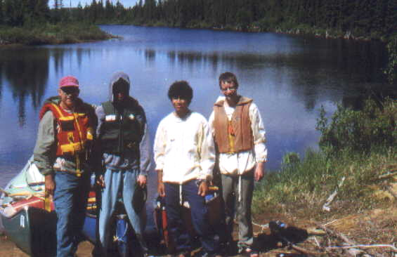
Alex Dearham Venturer
Dan Shore Venturer
Evan Van Neste Venturer
Barbara Bowman Advisor
Bill Bowman Advisor
The advisors accompanied us for safety and experience reasons.
Barbara was going because a female Venturer, Pam, was planning to
go, but had to cancel with a week to go. We decided that it
wouldn't be fair to Barbara as she had cleared her calendar
specifically for the trip so she went after all even though her
presence was not needed to complete the trip.
Introduction
The excursion we chose was a white water canoe trip in La
Vérendrye Wildlife Reserve, on the Chochocuane River. We had
wanted to do a white water canoe trip for a couple years. Several
members had gone on a week-long white water canoe trip a couple
years ago on the Petawawa River and they said it was fun. Some
members that had wanted to go, but couldn't wanted to have
another chance.
We chose the Chochocuane trip over other white water canoe trips
because it was the approximate length we desired and was at a
perfect difficulty level for our skills. We wanted a trip that
was fairly removed from civilization that was a route less
travelled.
Preparation
To prepare for this large undertaking, we did a lot of planning
and preparation. First off, we had to be qualified to paddle
whitewater rapids with something approaching confidence and
impunity. We attained this degree of confidence by taking
whitewater courses, hosted by the region and our company. These
beginner and intermediate courses, (Whitewater I and Whitewater
II respectively,) helped us to learn all the necessary skills
needed to take part in a week-long canoe trip, including scouting
the rapids before running them; the appropriate strokes needed to
perform certain manoeuvres as well as the light-weight camping we
would have to live with during the week.
Whitewater II was a course held on a section of the Madawaska
River which had a number of rapids in a short distance allowing
us to get the maximum amount of exposure to rapids, while still
being able to camp in one place. The rapids were relatively
challenging and, as a whole, we learned a great deal about
whitewater canoeing.
We had also done numerous other whitewater trips as a company.
This included a weekend trip on the Coulonge River and a
week-long trip on the Petawawa River which several of the
participants took part in. These trips had whet our appetites for
more adventure.
In addition to training, we needed to do a great deal of planning
to make sure that our trip went off without any hitches. This
included the need to plan a menu for each night and prepare the
food for each meal. We wanted to keep the food as light as
possible and because it all needed to fit into two waterproof
barrels along with the cooking utensils and the stove, it had to
take up as little space as possible. We made sure that we
dehydrated anything that could be dehydrated, which included
ground beef and tomato sauce, (for pasta,) in addition to many
other ingredients for our meals. Also, we discarded all the food
boxes because they took up too much space. We emptied their
contents into ziploc bags but cut out a part of the box and
slipped it in too so we would know what it was and how much
water, or other ingredients were needed. This was done for the
pancake mix, drink mix and any other powder we were taking with
us.
Long before we started planning the details of the trip, we
planned our route. We had decided on the Chochocuane River
because of its good reviews by other whitewater paddlers. We
decided on the 6-day trip which put in near Lac Cambrai and ended
at Outaouais, a car camping section of the Réserve Faunique La
Vérendrye, similar to Algonquin Park. The route would take us
past various historical landmarks, as well as give us several
campsite options each night. It would also put our paddling
skills to the ultimate test. To plan the route, we bought
topographic maps of the area which showed us the path of the
river as it winded through the park. When we arrived at the park
headquarters, we bought another map of the river. This map would
prove to be invaluable as it had all the designated campsites,
meal sites and each set of rapids marked on it, along with its
difficulty. Since we had these maps, we were able to plan where
we would have lunch, where we would camp and which sets of rapids
we would likely portage, all during the evening before we came to
them.
Sunday, July 2/00: Day 1
After packing on Canada Day, we gathered at Mr. Bowman's for
departure around 9:30 am. The van was loaded and on its way out
of the city by 10:30, making a non-stop trip to Maniwaki (via
highways 5, 105 & 117) where we stopped for lunch at the
local McDonalds. The opportunity was taken to purchase fishing
licenses for the Tuesday and Wednesday of the trip so that we
could eat fresh fish along the way. After several hours of
driving, we arrived at the park headquarters where we obtained a
permit to canoe in the "Reserve faunique la Verendrye"
region. We then proceeded to route 41 which was suggested by the
staff at the park. As we soon discovered, this route was old,
overgrown, and a lacking in functional bridges. We had to back
track over twenty kilometres back to the main highway in which we
lost about two hours time. After studying the maps, we found the
correct path to take (Chimo Rd.). We finally reached our
destination just in time for supper. We set up camp beside the
beginning point on the Chochocouane, ate and slept.
Terrain: -classic boreal forest environment
-Canadian shield
-swampy in parts
Plants & trees: -oxeye daisy
-orange hawkweed
-yellow hawkweed
-white birch
-black spruce
-poplar
-blueberry bushes
Animals/birds: -heard the calls of the white throated sparrow and
chickadee
-turkey vultures (2)
-black bear (1)
-ruffed grouse (1)
-black crows (many)
-snowshoe hares (many)
-moose (2)
Points of historical interest:
-clear cutting was easily noticeable around the area. In fact,
the road we came in on was mainly used as a logging road.
Location of downed bridge on route 41: 0345884 5289678
Location of first campsite: 0374572 5313373
Monday, July 3: Day 2
On this day, we broke camp and departed on our first day on the
river at around 11 o'clock. We went past the trashed hunters camp
that we drove by the day before. A short while after that, we saw
our first fast water section. However, it turned out to be a log
slide, and was therefore unrunable. Needless to say, we portaged
it. There was a long section of flatwater before our next
whitewater segment which was a mere Class I which didn't even
require detailed scouting. The next section of whitewater was a
long, very technical section with no clear channel, a Class III.
After scouting it for a good 15 minutes, we erred on the side of
discretion, and decided to portage it. The portage was rather
difficult though, as it was very overgrown and there was a 1.5
metre drop at the end. Still, we thought it was better to do this
than risk the rapids. The fourth set of rapids, a Class III was
very long and rough, so we eddied out in the middle to catch our
breath and scout ahead. The last set of rapids of the day was a
relatively easy Class I, barely worth mentioning. Once that last
section was out of the way, we searched for a campsite and, after
passing two unsuitable ones, we found a really nice one with room
for two tents and a firepit, something we couldn't say for the
first two. We were off the river and making camp by 6 o'clock.
The campsite co-ordinates were 0367606 - 5304822.
The terrain we encountered during the day included the winding
river, (of course,) sandy eskers, a lot of marshland, a
relatively weak current, and very disheartening sights of mass
clear-cutting, visible from the river. There were one or two rows
of trees facing the river before there was a barren, desolate
wasteland of tree stumps, tall weeds and fallen trees.
During the day, we came across the following examples of fauna:
blue flags, labrador tea, bunchberry, blueberry, yellow pond
lilies, cherry pine and balsam fir trees. We also saw several
animals including a heron, green frogs, cedar waxlings,
mergansers and what may have been an osprey. We also saw, (and
felt,) plenty of mosquitoes, black flies, deer flies and horse
flies.
While paddling on the river this day, we came across several
points of interest. For one, the log slide near the beginning of
the day's paddle was probably used by "les bûcherons"
(lumberjacks) to bring logs down the river. At the bottom of the
log slide, there was a long steel cable resting on the shore
which was probably used to stop the logs as they came down the
slide. There was also the ever-present view of clear-cut forest
throughout the day.
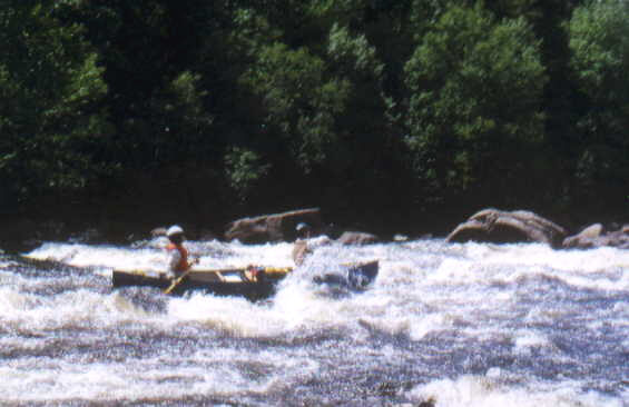
Tuesday July 4: Day 3
On Tuesday, we paddled along the fairly narrow, winding river
through very wooded areas. We came across 3 sets of rapids and no
portages were necessary. The first one was a difficult Class III
which required a large amount of scouting as there were several
ledges we had to dodge. The second was merely a swift, just fast
moving water. The last set of rapids was a Class II-III. Not much
scouting was needed as it was fairly straightforward. During the
day we came across two kayakers who were paddling upstream, in
the opposite direction we were. This day was the only day when
the weather was not as favourable as the other days. At around 3
o'clock, it started raining fairly hard off and on for about an
hour with a couple cracks of thunder in the distance. When we
finally reached the campsite we had decided upon the night
before, we prepared our dinner and went to bed. This was by far
the nicest campsite of all. There was a nice sandy beach perfect
for a campfire, no steep eskers like some of our other sites.
Some earlier campers had set up a flat rock so it could be used
as a table. We set up our tents on a rise next to the beach
populated with tall majestic white pines. The campsite's
co-ordinates were 0360586 - 5297268.
This was the first day in which we encountered rocks on the
shore. We had lunch on a very large slab of rock overlooking some
rapids. We noticed somewhat less clear-cutting, but it was still
present nonetheless.
In addition to all the plant life we saw the previous days, we
also saw maple trees, ferns, cherry bushes and some jack pine
trees. We saw many animals including red squirrels, chipmunks,
American toads, leeches and a Spotted sandpiper.
This day, was the day during which we came across the indian
campground. It would best be described as a junk heap with lots
of garbage a while ago, including a toilet seat, a gas can, an
old kitchen sink and empty cans of food and baking powder. These
items were found in and around a short, dilapidated pressboard
cabin. We also came across an old logging road that ran parallel
to the river. There were several small, washed out bridges on
this road that may or may not have been the original road we had
taken which we were unable to use to get to the first night's
campsite. At the bottom of one of the rapids, we found more steel
cable and a steel hook anchored to the ground, a definite sign of
past logging.
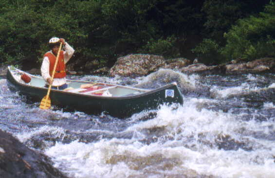
Wednesday July 5: Day 4
We awoke the next morning, packed up and took off. The first 10km
of today's paddling was a long stretch of mundane flatwater
punctuated with three short and easy class I rapids. We then
arrived at an island portage. To the left of the island was a
class IV rapid which we decided we wouldn't run. To the right
there was supposed to be some cascades but these were
inexplicably dry so the island was connected to land. We noticed
on the map that there was an old cabin on the shore next to the
island which we decided to explore. The cabin seemed to be
several decades old with old newspapers and canned food lying
around. We also noticed a rudimentary French grammar book.
Perhaps the cabin used to be occupied by some Native people who
were trying to learn French. We went back to the island and
checked out the campsite there. It was a very nice spot, open
with a fire pit, but there was still a lot of time left before
dinner so we eventually decided to press on about 3km to the next
group site. Along the way, passed by a really good class III with
some really huge haystacks. Evan and Dan almost swamped, taking
on so much water but managed to save themselves by frantically
bailing water out even before the rapids were finished. Alex was
soloing and was unable to control his boat enough to hit the best
part of the swells. After the end of the day treat, we continued
on to our site and set up camp.
The terrain we met during the day was very similar to the days
before, with a weak current on the winding river surrounded by
coniferous forest. The banks of the river were mainly sandy
eskers and just beyond the bank, visible from the river, there
were, again, characteristic signs of heavy deforestation.
In proportion with the other days, this day was relatively
monotonous when it came to plant life as we did not come across
any plants that we had not already seen. We did however see some
Vetch in addition to the now familiar jack pine trees, yellow
pond lilies and blue flags. We also saw mergansers on several
occasions including a mother with about 10 ducklings following
closely behind. We saw some moose tracks in three spots along the
river as well as some deer droppings and hair. We heard a toad
and we caught and our advisor caught a pike, (grand brochet du
nord,) which we cooked up for dinner in addition to our planned
dinner.
We paddled past an old overgrown logging road with a bridge that
had been washed out. There was also a hunt cabin which had been
used fairly recently, (maybe a couple of years ago). As we peered
through the windows, we saw old food containers, photographs,
snowshoes hanging on the wall, a french spelling book lying on
the table and a bottle of whiskey. We also paddled by an old
logging grave, which had been marked on the map. It was a simple
large wooden cross with a small statue of Mary and some ceramic
roses. We're still not sure about the circumstances surrounding
its placement there.
Thursday, July 6: Day 5
Description of route taken:
We left our camp site and headed off after about 3km of
travelling, we came upon our next set of rapids and yes, another
"pont détruit"! We quickly scouted the rapids from our
boats (they were marked as a class II followed by a class I) and
decided they looked easy. After running the short distance with
no trouble whatsoever, we decided they were probably only swift
to class I. After a long 7km paddle, we finally reached one of
the highlights of the trip: the Grand Chute. This was a 100 class
II rapid followed by a steep class IV chute. After eating lunch
and scouting the rapids, we decided we would never jump the class
IV and stay afloat, let alone be able to escape the deadly
hydraulics the size of a small bungalow at the bottom. We were,
however, confident that we could easily negociate the class II at
the top and eddy off before hitting the chute itself. This kept
us from having to portage our gear too far. We managed to run the
top part one canoe at a time, with someone standing by with a
throw rope before the chute - just in case. We then safely
portaged the thirty or so metres to the bottom and shoved off.
After taking a few moments for a photo op, we turned away from
the sight and used the strong currents to propel us down the
river. We travelled another 6km without meeting anything more
formidable than a very short class I. We eventually reached a
rapid marked class V on our map. This was about a 50 metre rapid
which owed its difficulty to the succession of ginormous
hydraulics which were to be found along the way. We decided to
portage the part with the hydraulics, but run the easier portion
at the bottom. we dragged our canoes over a rock outcropping to
the left of the rapids put in. As it was nearing the end of our
paddling day, we stopped at the next camping site, about 1.5km
down the river, set up camp, had dinner and settled in for the
night.
Terrain:
Same as usual, many eskers today.
Plants and trees:
- cedar
- white spruce
- raspberry bushes
- spring beauty
Animals and Birds
- snake
- sparrow
- wood frog
- merganser ducks
- beaver lodges
- huge pike
Points of Historical Interest
We came upon another ?pont détruit? situated beside an old
native camp. We found a cement foundation of an old building as
well as some wooden poles set up like some kind of rack.
The Grand Chutes is also worth mentioning - it is a very
important and recognizable landmark which is also very beautiful.
Friday July 7: Day 6
We got up the next day, breakfasted and broke camp, anticipating
our last day of white water on the trip. It took a long 8km to
bring us to our next rapids - a nice long 600m set of alternating
class I-II with a little class III thrown in for good measure.
After hopping out to scout the length, we decided it was all
doable. We ran most of it, did eddy turns behind yet another
infamous "pont détruit" and had lunch in a clearing
overlooking the rapids. After our brake, we practiced some eddy
turns and ferrying, using the eddies created by the destroyed
bridge and left continued down the river. 4km later, we shot down
a quick class II and came upon the last set of rapids on the
trip. The book called these rapids a class IV followed by a class
II for about 500m but it cautioned that the rapids are
non-existent when the water level of the Dozois reservoir is
high. We discovered to our chagrin that this was partly the case;
the rapid had been reduced to an easy swift which was easily
negociated. We continued some 5km to our next camp site. Upon
arriving however, we decided, since it was still only about 3:00,
that we had covered relatively little ground that day, that we
would press on into the Dozois reservoir and finish all our
paddling that day. We thought that this way, we could all get
back to Ottawa the next day in time for supper. We entered the
reservoir, which was like a huge lake with many small islands and
huge tree trunks sticking eerily out of the water. The going was
tough because of the wind and we were worried about losing our
way because of the uniform looking terrain and the multitude of
islands and passages. Sure enough, Alex made a wrong turn between
two of the islands and we went about a kilometre off course
before he realised his error. We quickly stopped, took a GPS
reading, located our position on the map and plotted a new route.
We negociated the rest of the islands without incident and
emerged into the main, and more open, part of the reservoir.
Rounding a corner, we finally caught sight of our destination.
The causeway of highway stretched before us, the cars whizzing
along at breakneck speed and, nestled between its two stretches,
lay the island site of the Outaouais Campground. With renewed
energy, we paddled the last 5km of the journey, passed under the
highway bridge and beached our canoes on the sandy shore of the
island. After transporting our gear to our site and setting up
camp for one last time, Alex discovered that he had left his
lights on in his car for five whole days!! The battery was
obviously dead. This posed little problem for us since it was the
summer, and there were tons of people at the outaouais
campground. Alex and Barbara found a native man who was willing
to give the car a boost using his pickup truck. As an added
bonus, the man (who used to be a guide in the area before it
became a nature reserve) was able to give tell us what
Chochocuane means. He used the adjectives ?flowing?, ?slippery?
and ?sliding?to describe the word. After boosting the car letting
it run for about half an hour and a quick meal, we all settled
down to sleep, exhausted in the knowledge that we had paddled a
full 22km that day.
Terrain
same as usual along the river.
Dauzois Reservoir: A huge body of water resembling a lake but
with a strange feature: everywhere in the water there were
thousands of sawed off tree trunks, some sticking out of the
water, some laying just below the surface.
Plants and Trees
nothing new of note.
Animals and birds
- bluejay
- ringbill gull
- ravens
- spotted sandpiper
- black duck
- tree swallow
- pike
- bank swallow
- Merganser duck with about 2 dozen chicks
Points of Historical Interest
The Dozois Reservoir, created by dams used to control the water
level of the Ottawa River was built in the 1930s as a make work
project. The reservoir is an ideal habitat for fish and is
therefore a popular area for Quebec fishermen.
Saturday July 8: Day 7
Alex and Bill woke up early (about 6:30) on Saturday morning to
the sound of the ravens, crying to each other as they sailed
about over the island campsite. Alex drove the 136km to the put
in where Bill?s van was parked. They drove into the campsite
about two and a half hours after they had left. We then packed
the two vehicles and left for Ottawa. We stopped for a quick
brake to take a look at the covered bridge over the rapids at
Grand Remous (French for ?Big Eddy?) and continued on to have
lunch at the McDonalds in Maniwaki. Alex, Dan and Evan then
headed for Ottawa and Bill and Barbara for their cottage just
outside of Maniwaki. The rest of the drive was uneventful. The
total distance travelled by Alex?s car by the end of the day was
656km. The three venturers, exhausted by their long journey,
retired to their homes, safely nestled within the familiar bounds
of civilization.
Terrain
Plants and Trees
white pines
Animals and Birds
- ravens
- ruffed grouse and 2 chicks
- groundhogs
- skunk
- ringbilled seagull
- chipmunk
Points of Historical Interest
Covered bridge at Grand Remous.
A brief history of the Chochocuane River
taken from a French guide book at Le Domaine
The name Chochocuane, has appeared on several documents as early
as the 19th century. For example, Eugène Taché?s map (1870)
mentions the Rivière Shesheinquanne. Albert Peter Low, in his
report of 1896, indicated the Sho-Sho-quan River. The two
editions of the ?Dictionnaire des rivières et lacs de la
province de Québec? (?Dictionary of the Lakes and Rivers of the
Province of Quebec?) 1914 and 1915, show the rivière Shoshokwan
and translate the Algonquin to ?river where the ice cracks.
Furthermore on the subject of the meaning of the word,
Joseph-Étienne Guinard, in 1960 wrote: ?Chochokwa, comes from
the roots ?cho-cho?, meaning sliding, smooth and ?mikwan? meaning
ice.